
General News » News
Ward options presented ahead of Wednesday meeting
December 5, 2019 · 0 Comments
Aurora is set to begin the next phase of the possible implementation of a “ward” system of governance.
Earlier this week, the Town released the preliminary findings of a consultant’s report, the next step in moving the Town away from its current “at-large” system of governance where a Mayor and Council of six members represent the whole Town towards a “ward” system where specific neighbourhoods would be represented by a single member of Council plus the Mayor.
The findings were prepared by Beate Bowron Etcetera, Hemson Consulting Ltd., and The Davidson Group, who have spent the last few months holding public information sessions eliciting feedback on the possible switch from members of the community, as well as compiling results from online polls and questionnaires, and the resulting report outlines four possible ways Aurora can be divided up into wards, with models including options with three, four, five and six wards respectively.
“Any ward system that is established in a municipality must achieve ‘effective representation,’” said the consultants in their report. “This is an inclusive term used to assess how well residents are represented in our form of government, which we call ‘representative democracy.’ At a general level, it means that one person’s vote should be of similar weight to another person’s vote. When applied to wards, it suggests that wards have similar populations.”
In weighing the options, consultants considered natural and physical boundaries in Aurora, including major arterial roads and the railway tracks, communities of interest, including Aurora’s so-called Stable Neighbourhoods, and voter parity.
Additional factors included the capacity of a single member to represent areas of varying size, the sizes and shapes of possible wards themselves, and future population growth.
“Population growth has to be taken into consideration, if a ward system is to last for multiple elections,” they said. “Any new ward system should last Aurora for three elections – 2022, 2026, and 2030 – and possibly a fourth, 2034.
“Designing a ward structure requires balancing the many components of effective representation. While all of the components have to be taken into consideration, they are not all equal. Voter parity is pivotal and is a key determinant of effective representation. Respecting communities of interest is another high priority, along with well-defined, coherent ward boundaries.”
The four options that will be before members of the public at the December 11 public meeting, and again at a session this January, proved challenging due to “the Town’s geography, varying densities and distribution of populations, the different street patterns in the older and newer parts of Town and those in areas where future growth will occur.”
Next week’s public meeting will take place December 11 from 7 – 9 p.m. in the Town Hall’s Skylight Gallery. A further session will be held at the Aurora Cultural Centre from 7 – 9 p.m. on January 15.
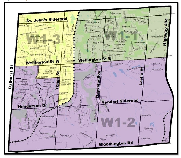
OPTION #1 – THREE WARDS
In the first model, Ward 1 would be roughly bordered by the town’s northern boundary, Highway 404 in the east, Wellington Street East in the South, and the rail line in the west. Ward 2 would be bordered by Wellington in the north, the 404 on the east, Bloomington Road in the south and roughly Bathurst Street in the east, with a section of the Downtown Core allocated to Ward 3. The proposed southern boundary for Ward 3 runs from Bathurst in the west, heading east along Wellington to Murray Drive, dipping south to Kennedy Street and across to Yonge and down to just south of Allaura Boulevard before meeting its eastern boundary, which runs along the train tracks to the Newmarket border.
In this mode, Ward 1 would have an estimated population of 25,520 in 2026, while the populations in Wards 2 and 3 would be 21,260 and 20,780 respectively.
“In the Three Ward option, there would have to be more than one Councillor per ward to meet the Municipal Act requirement of a minimum Council size of five members, including the Mayor. Electing two Councillors per ward would be the most direct way of implementing Option 1. The result would be a Council of seven members. A Deputy Mayor would have to be elected by Council or appointed by the Mayor. Another approach would be to reduce Council size to five members. In this configuration, there would be one Councillor per ward, plus a Mayor and a Deputy Mayor at-large.”
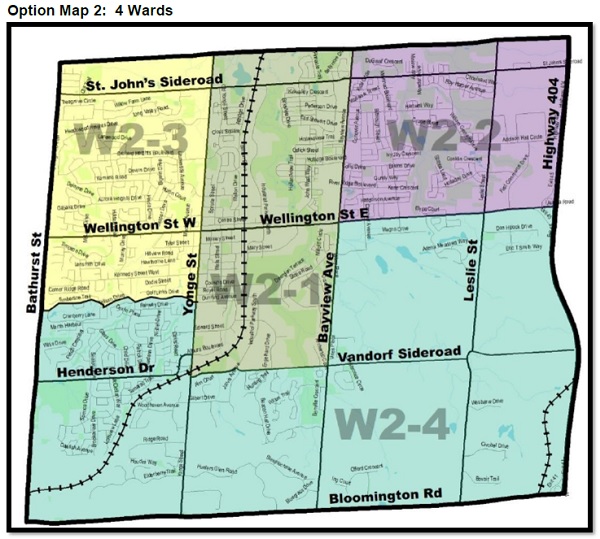
OPTION #2 – FOUR WARDS
In this model, the first proposed ward would be bordered by Newmarket in the north, Bayview in the east, Vandorf Sideroad/Industrial Parkway South in the south, and Yonge Street in the west. Ward 2 would be bordered by Newmarket in the north, the 404 in the east, Wellington Street in the south, and Bayview in the west. Ward 3’s borders would include Newmarket in the north, Yonge Street in the east, roughly the Golf Links Drive community in the south, stretching to Bathurst, the ward’s western edge. Ward Four would be bordered by the Golf Links Drive community, Vandorf and Wellington Street to the north, and by the 404, Bloomington and Bathurst on the remaining four sides.
This would result in an average ward population of 17,000 in 2026.
“This option would lead to a Council of five members, four ward Councillors, plus the Mayor. A Deputy Mayor could be elected by Council or appointed by the Mayor. If a slightly larger Council was desirable, a Deputy Mayor could be elected at-large for a Council of six members.”
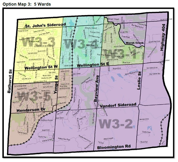
OPTION #3 – FIVE WARDS
This option, says consultants, keeps communities together while using major roads as ward boundaries.
Ward 1 would be bordered by Marsh Creek in the north, Leslie Street to the east, Wellington Street to the South, and Bayview Avenue to the north. Ward 2 would be bordered by Newmarket in the north, the 404 in the east, Wellington in the south, and Marsh Creek in the west. Ward 3 would run across the Newmarket border from Bathurst in the west to Yonge Street in the east, running south to Kennedy Street West. Ward 4 would run from Yonge in the west, across the northern Newmarket border to Bayview, running south to Wellington Street. Ward 5’s boundaries would be the railway in the east, and south, Bathurst in the west, and Kennedy Street West to Yonge in the north, with the southeast quadrant of Yonge and Wellington falling in this area as well.
This option would leave each ward with an average population of 13,600 in 2026.
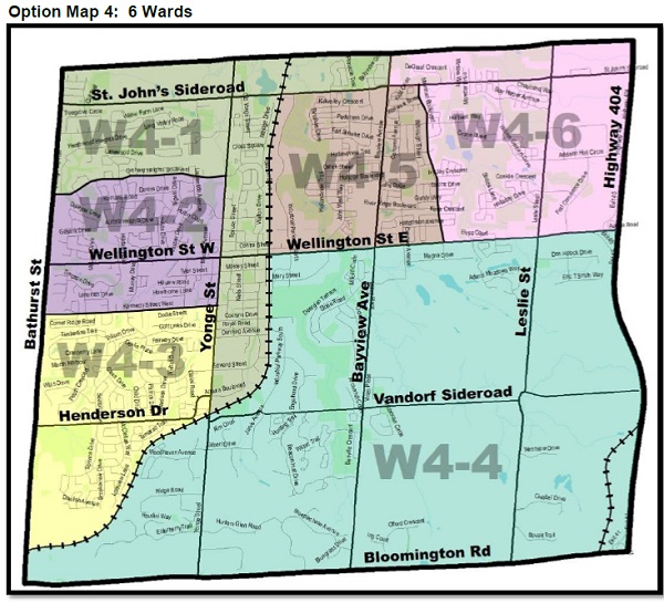
OPTION #4 – SIX WARDS
This option would leave the Council at six members plus the Mayor, but results in a more complex boundary configuration. Ward 1 would run along the Newmarket border eastward to the railway, which would be its eastern border. The ward boundary would include the east side of Yonge Street up to Orchard Heights Boulevard and running westward to Bathurst. Ward 2 is bordered by Orchard Heights, Yonge Street, Kennedy Street West and Bathurst. Ward 3 uses Kennedy as the northern boundary, while the eastern edge is found along Yonge Street to the railway tracks, which is its southern boundary to Bathurst. Ward 4’s western edge is the railway tracks running north to Wellington Street, east to the 404 and south to Bloomington. Ward 5 is edged by Wellington Street in the south, the railway in the west, St. John’s Sideroad in the north, and roughly Mavrinac Boulevard in the west. Mavrinac is largely the western edge of Ward 6, which uses Newmarket as the northern border, the 404 as the eastern border, and Wellington as the southern edge.
The map results in an average ward population of 11,330 in 2026.
By Brock Weir


Readers Comments (0)
Headline News
Aurora Lions Club celebrates 80 years of community service
.
George Street PS site secured by Town for parkland, redevelopment
George Street Public School, and its surrounding property, have been secured by the Town of Aurora for parkland and redevelopment. The Town announced the $10,722,000 ...
Addressing income struggles is key to battling food insecurity: YRFN
As important as food banks are to communities like Aurora, addressing income inequality will be the key to tackling food insecurity, according to the York ...
Electric Vehicle Showcase zooms into SARC for reimagined event
The ins and outs of electric vehicles (EVs) will be in the spotlight on Sunday, April 28, as the Town of Aurora’s Electric Vehicle Showcase ...


